OASIS 2.0
The Center for Urban Research at the CUNY Graduate Center has updated & enhanced OASIS's interactive maps. Click the links below for information about the changes.
Jump to:
Updates
New for 2010:- New data from NYC agencies: the NYC Dept of City Planning now provides zoning data (not only R, C, M zones, etc, but special districts, commercial overlays, and E & D designations), and the NYC Landmarks Preservation Commission has provided OASIS with their latest landmarked properties and historic district boundaries.
- Shortcut searches: we've added a third "tab" (right next to the Location Report tab) that provides quick search options for community gardens, local environmental stewards, and other key features;
- Feature-specific links: you can click on www.oasisnyc.net/map.aspx?zoomto=garden:774 or www.oasisnyc.net/map.aspx?zoomto=address:365 5th Ave, Manhattan or www.oasisnyc.net/map.aspx?zoomto=lot:1001220001 and go directly to these locations. In other words, each and every garden, street address, and tax parcel will have its own OASIS link. We'll likely expand this for other types of sites. These feature-specific links will make it easier for people to access particular locations on the map.
- links to online maps for Westchester and Nassau counties and northern New Jersey.
Earlier updates (circa Fall 2009; thanks for everyone's feedback!):
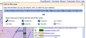
- print your map: you can print your map with a custom title or save the map image itself as a PNG graphic;
- permanent link to your map: you can copy a link to each map you've made and
share it via Twitter, email, IM, del.icio.us, blog post, or other online link;
- easy searches for stewardship "turfs": in partnership with the USDA Forest Service (see update below), we've created a special search feature so you can locate stewardship groups and their "turfs" by name, type, region, and group focus;
- links to Mannahatta: when you click on the map anywhere in Manhattan, we provide a link to the Mannahatta website so you can explore in rich detail what that spot of land looked like, and what eco-systems were around it, circa 1609.
Overall, we have:
- made it easier to navigate the map -- you can drag the map and zoom in/out just like in Google Maps;
- updated the mapping software so the maps are quicker and look better (special thanks to ESRI's NYC office for the terrain background and a template for labeling subway routes) -- and we've combined the latest ESRI software with powerful & flexible open source tools (such as OpenLayers and Ext JS);
- added environmental stewardship "turfs" (from the Forest Service) and historical land use for Manhattan and the Bronx River (from the Wildlife Conservation Society), as well as Census data, libraries, subsidized housing, and environmental remediation sites;
- integrated Yahoo! local search results -- when you enter a street address or click on a tax parcel, you'll see a list of businesses at that location;
- updated existing information with the latest property data, open space sites, harbor habitats, public access to the waterfront, schools, and more; and
- added new features such as:
- a timeline slider
 to seamlessly transition between aerial photos from 1996 and 2006,
 - a dynamic transparency control
 so you can set the transparency level for any layer on the map to reveal
what's underneath, and
so you can set the transparency level for any layer on the map to reveal
what's underneath, and - Microsoft's bird's eye views of any spot on the map (via Bing). Click the map, then click the camera
 marker. "Right click" the camera marker to remove it. Remember to look in the "Location
Report" for the spot you clicked -- this info will change depending on how close
you're zoomed in and what Legend items are checked.
marker. "Right click" the camera marker to remove it. Remember to look in the "Location
Report" for the spot you clicked -- this info will change depending on how close
you're zoomed in and what Legend items are checked.
- a timeline slider
Now it's just as easy to zoom to a property (or community garden, stewardship "turf", or waterfront site) as it is to develop a richly-layered map of land use patterns, aerial views, and open space resources in each borough and citywide.
Return to top
Feedback
Please send us feedback, such as:
- Are the maps easy to read? Are features on the map labeled clearly?
- Are the search tools (above the map) helpful in locating properties, neighborhoods, ZIP Codes, etc?
- When you zoom to a parcel or click on the map, is the "Location Report" information presented clearly?
- Are the new tools easy to access, easy to use, and helpful?
- What else would you like us to add, or is there anything we should remove -- anything too distracting, extraneous, etc?
Return to top
Credits
The OASIS website was redesigned by the CUNY Mapping Service at the Center for Urban Research. In particular, David Burgoon completely reprogrammed and recoded the site to create a powerful but easy to use application, one that can be relatively easily extended and modified. He identified and integrated the best and most helpful aspects of several open source applications (more on that below) with ESRI software in creative and pathbreaking ways. Two people who've been involved with OASIS from its inception -- Christy Spielman and Steven Romalewski -- redesigned the website and maps. Christy helped develop the cartographic design of the map layers, created several of the website's graphic elements and navigation tools, and provided invaluable guidance and insights. Steve updated the data sets, worked with Christy on the cartography, and guided the overall effort. Throughout this process we worked closely with other OASIS steering committee members and other OASIS website users who provided great feedback.
The work was supported financially by several sources, including a major gift to the Graduate Center from the Double-R Foundation, grant support from the USDA Forest Service, US EPA (through the New England Interstate Water Pollution Control Commission), and the Wildlife Conservation Society, and direct support through CUNY and the Graduate Center. If you'd like to help us continue to provide this valuable mapping service, please consider making an online donation (select "OASIS Project/Center for Urban Research" as your designated donation).
OASIS has always been a collaborative partnership, and the newest version of the website features data and maps from new and long-standing partners (see our Wiki for more background). These include the Mannahatta Project at the Wildlife Conservation Society, the Stewardship Mapping Project of the USDA Forest Service, the US EPA's Harbor Estuary Program and the US Army Corps of Engineers, and the Council on the Environment of NYC community gardens program.
ESRI's New York City office -- in particular, Patrick Gahagan -- helped create the new look of the OASIS maps. Patrick developed the ArcGIS techniques we used to create the map of subway stations and routes, and also provided a terrain model database (DEM mosaic) that we used as a backdrop for the new OASIS map.
The new version of OASIS would not be possible without great improvements to ESRI's GIS software plus the emergence of production-level open source applications. We used a combination of ESRI's ArcGIS Server (and ArcSDE running on Microsoft's SQL Server database engine), the open source map viewing library OpenLayers, and the JavaScript web framework Ext JS. We first used this combination of web mapping tools and techniques for the Long Island Index interactive map, and we plan to continue to enhance both applications with feedback from users of each website.
Return to top
Coming Soon
The new OASIS website is a work in progress. Here are some features we plan to add in 2010:
- New data: the NYC Soil & Water Conservation District has provided us with a groundbreaking (no pun intended) data set of soil types across the city -- we'll be adding all this and more to OASIS soon.
- Historical land use patterns: we'll be mapping the parcel-by-parcel land use data going back to the late 1990s. You'll be able to transition between years to see how development patterns have changed locally and citywide.
- Street tree data from Parks Dept's 2005 Census: we're working with Parks to aggregate their 2005 Census data by block group, so you can map key patterns citywide. We also hope to add the same type of data from the 1995 Tree Census so you can see change over time.
- Flickr and more: we'll be adding Flickr feeds, more map data via web services, and other social networking features (such as user reviews and updates).
- More map data: more detailed information in New Jersey, regional Census demographics, and more.
- Your suggestions: let us know what you think and we'll consider adding it. See the OASIS data guidelines for ideas.
Return to top
The new OASIS maps work best when viewed with:
- Firefox 2.0 or higher [download Firefox]
- Internet Explorer 7.0 or higher [download IE]
Return to top
Updated February 2010